Innovations across the transport and energy sectors are expected to fuel the largest spend in smart city development over thInnovations across the transport and energy sectors are expected to fuel the largest spend in smart city development over the coming decade, with global expenditure reaching nearly $124 billion in 2020 . The vision of a fully connected city through technological innovations have already surpassed what existing current infrastructure can provide. That said, some advancements in this sector are already playing a huge role underpinning safety of operations throughout Europe – UK, Germany, Belgium – to name a few.
Smart sensing solutions are becoming an essential part of the technology needed to improve the safety of public operations across a myriad of local infrastructure, from streets, roadways, and intersections to buildings and other public spaces. These systems are already making a difference and are allowing us to envisage the future of cities based on interconnectivity and, in turn, situational awareness and data driven operations. A key question we must now ask is: how can local authorities tap into the technology and infrastructure already available to make this vision a reality?
Thermal transport solutions
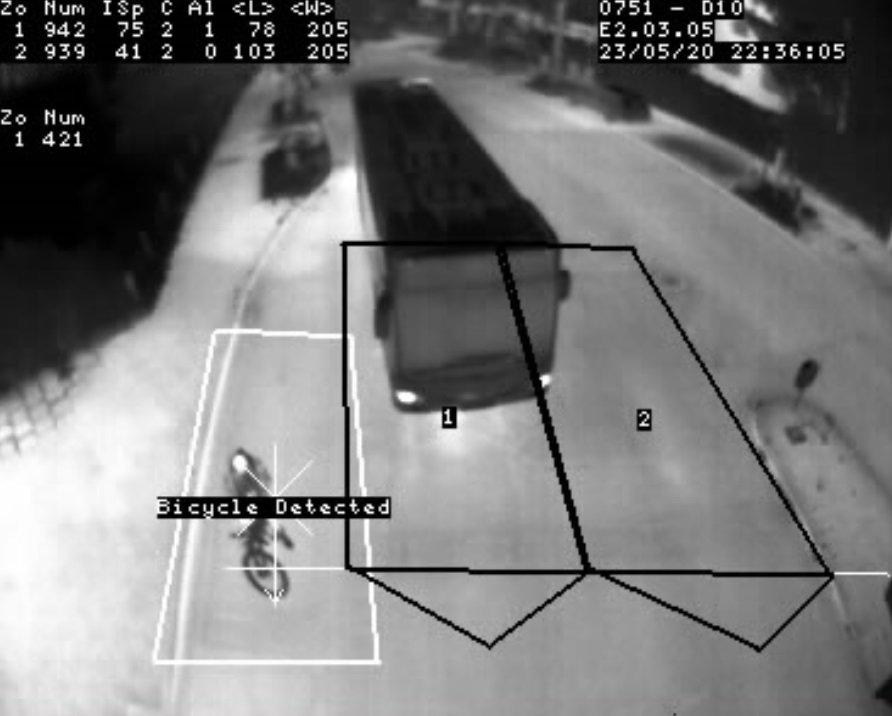
A critical aspect of intelligent transport systems is thermal imaging. The technology works through tracking heat movement in any situation or condition, and therefore can be used in a safety capacity through extending the visibility of traditional cameras by up to four-times. This has been rolled out in many cities across the globe. Intelligent transportation solutions such as smart thermal and visible imaging systems that monitor traffic flow and detect incidents can empower cities to better inform road users of hazards, delays and alternate routes to keep everyone moving.
Hamburg, which has previously been named one of the most congested cities in Germany, is building a name for itself as the most innovative smart city in the country. Smart solutions provide resolution to the issue Hamburg’s commuters face, with 113 hours a year being wasted to traffic jams – by providing a better picture of traffic dynamics. City authorities are installing thermal imaging technology to traffic and street lights which will allow authorities to “see” data-points. These cameras are interconnected via a cloud-based system which will allow for high-resolution and real-time information to be collected and analysed, resulting in fully comprehensive datasets from all 420 intersections across the city.
Traffic controllers can differentiate between pedestrians, vehicle types, and cyclists allowing them to accurately count and process how busy the roads are. This provides cloud-based control systems with invaluable data which enables them to adjust signals in real-time. Furthermore, information can be seamless transferred across the city, meaning that controllers can improve long-term planning and reduce blockages, so traffic flow is adapted to minimise daily congestion.
Enhancing visual awareness
Advancements in traffic systems are already playing a huge role in the safety of operations across cities globally. For example, authorities in the UK, including the City of Durham recently deployed FLIR thermal imaging sensors onto pre-existing road signs to build a unique collision avoidance system that reduced the number of incidents at the junction to zero. By putting electronic road signs that spur signalisation into action upon the detection of a passing object has helped prevent crashes and ultimately save lives. Over-time this can change driver behaviour through early-warning systems that prevent heavy breaking, allow drivers to adapt their speed accordingly and drive more economically.
Having this data to hand enables city authorities to analyse the information which can be used to optimise infrastructure performance and make roads safer. By getting ahead of rush hour on busy arterials to posting travel-times on variable messaging boards, technology is enabling urban planners and dwellers to make safer and smarter transport decisions.
Driven by data connectivity
With city operators and first responders sharing data and detecting incidents in real-time, more collaborative and efficient interactions are enabled, and safety can be maximised. Working with a single platform for data sharing, inter-device connectivity and end-user infrastructures all provide greater control for command centres to enhance public safety operations.
The flexibility and scalability of cloud platforms enable these solutions to be tailored to address specific needs – those that operate seamlessly within any city- or urban-level operation, management platform, and associated interface. Through one central node of communication, command centres can monitor their environment from a single access point. On top of this, AI driven-data processing allows for a faster, more unified response across the city, regardless of the scenario.
By connecting cities through intelligent transportation solutions – like FLIR smart thermal and visible imaging systems that monitor traffic flow and detect incidents – we can better inform travellers of hazards, delays and alternate routes to keep people moving. These systems are already making a difference and allow for the visualisation of a future connected city based on situational awareness and data-driven operations.
The ideas and understandings behind smart cities are constantly changing while their purpose remains, and should always remain, centred on public safety.
While the vision of a fully connected city has exceeded what the current infrastructure can provide, we’ve seen through city operations in Hamburg and Durham, that it’s possible to transform existing infrastructure into part of an interconnected ecosystem of technologies. Through this, citizens are kept better informed of hazards, delays, and alternative routes – keeping cities moving and communities safe.
Founded in 1978, FLIR Systems is a world-leading industrial technology company focused on intelligent sensing solutions for defense, industrial, and commercial applications. FLIR Systems‘ vision is to be "The World’s Sixth Sense, creating technologies to help professionals make more informed decisions that save lives and livelihoods. For more information, please visit www.flir.com and follow @flir.
Teledyne FLIR
Schwieberdinger Straße 60
71636 Ludwigsburg
Telefon: +49 (7141) 488817-0
Telefax: +49 (7141) 488817-99
http://www.flir.de/MV
Press
Telefon: +34 (602) 102-965
E-Mail: n.bazerbachi@mepax.com
![]()

